Carluke is an old market town at an important crossroads between central and southern Scotland, where old and new roads converge. Once out of Carluke the road is lined with beech and hawthorn.Good views in every direction, especially to Tinto and across the Clyde Valley to Blackhill.
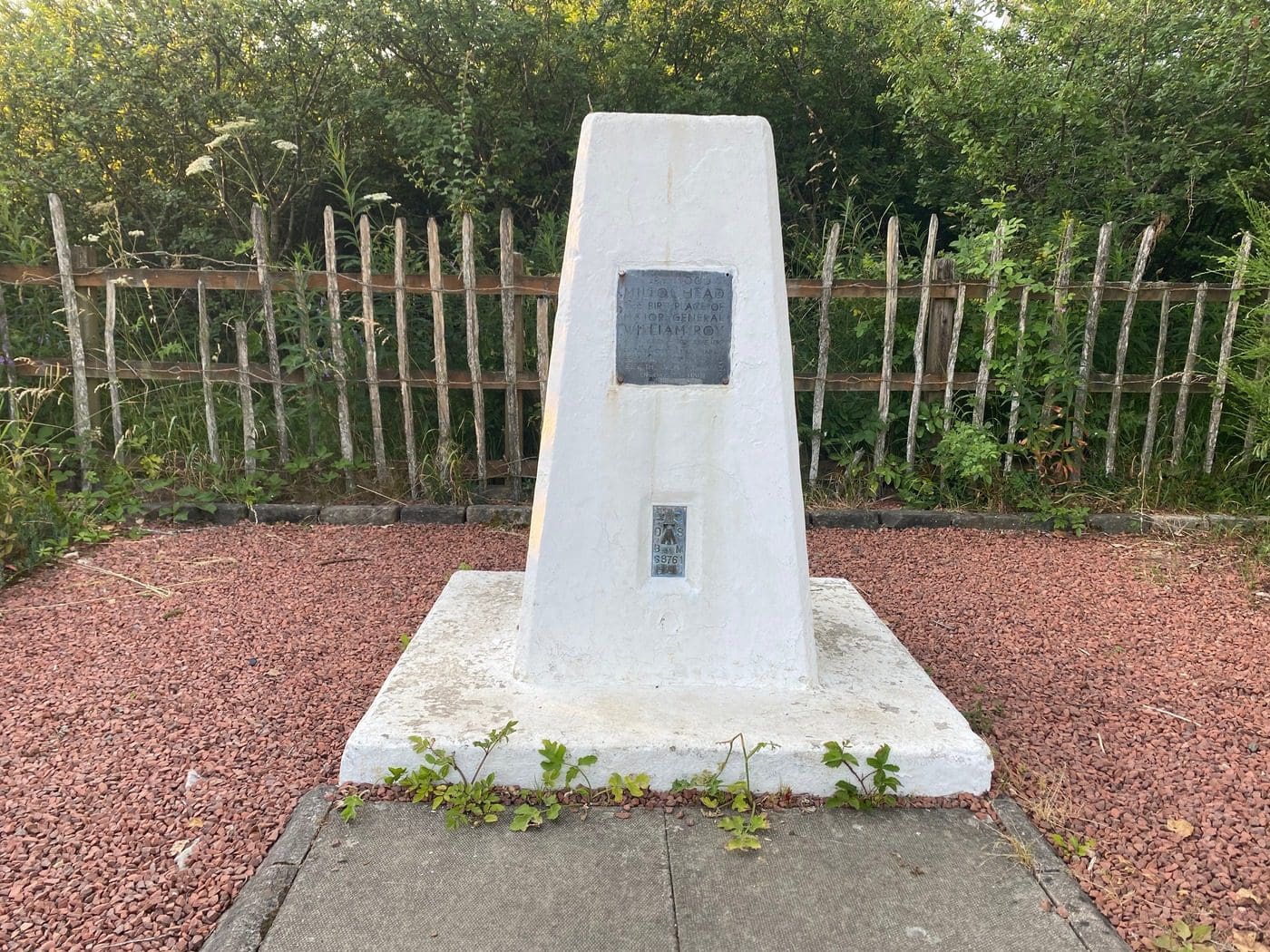
In 1956, a monument in the form of a Trig Point was erected by Ordnance Survey in honour of surveyor and map-maker Major General Roy. The memorial is located at Multonhead, near Carluke, where Roy was born. The plaque reads: “Here stood Miltonhead the birthplace of Major General William Roy 1726-1790 from whose Military Map of Scotland made in 1747-1755 grew the Ordnance Survey of Great Britain.”
The River Clyde starts at an altitude of 472 metres in the Lowther Hills in South Lanarkshire and trails more than 100 miles to the sea. It flows north through South Lanarkshire then turns west and passes through the former industrial village of New Lanark. Here, the river cascades through the Falls of Clyde before the Clyde heads north-west through Clydesdale and on to the city of Glasgow where it widens and forms the Firth of Clyde.
A stream rushes through the surprisingly dramatic wooded gorge, which is also a Special Site of Scientific Interest (SSSI).
A 40 mile/65km riverside footpath from the centre of Glasgow to the Falls of Clyde at New Lanark.
Start in Carluke at the junction of Market Place Road and High Street. Continue along High Street to a roundabout then take right on to John Street
At the junction of John Street and James Street, take the left turn staying on John Street. You will cross a burn and head uphill. This eventually turns into Old Lanark Road.
At the junction of Wilton Street, cross the road going diagonally left into the new houses at Balcastle Cres.
At the “V” in the road, take the right fork and continue straight ahead on the path between the houses to join Old Lanark Road.
Eventually, you meet crossroads with Goremire Road. Go straight ahead on Old Lanark Road. (This looks more like a track than a road and is not suitable for cars.)
At crossroads with Boghall Road continue straight ahead.
Continue until another crossroads. The road naturally bends to the left. At this point, turn right and go through a gate.
Follow a track (Meadow Road) all the way down to the railway.
Cross the railway bridge and continue. You’ll be able to see Tinto Hill from here.
At the main road (A73), cross the road, (take care with this crossing on a busy road). Head down Auchenglen Road. This goes some distance and through Fiddler’s Gill.
When you reach the house at the bottom, take the path to the right and follow a sign to Birkhill Road.
At a junction of Birkhill Road with Nemphar Moor Road, turn right and then left onto Braidwood Road. Cross the road and continue into Crossford.
Just before the river, there is a big signpost to the River Clyde Walkway. Turn here and take the path right. Keep going. At one point the path splits. You can take either side as they join together again.
Continue on the Walkway before coming back up on to a road.
Note: There are some bits of broken boardwalk (diversion in place).
Look for a large house at Milton-Lockhart. There are signs stating where the public can go and where is private. These should be adhered to.
On reaching Milton Road, continue ahead and pass a monument for Major General Roy.
From the monument continue along Milton Road to the junction of Station Road, then turn left on to Station Road.
As you turn into Station Road, on the right there are new paths. These are a nice addition if you want to do more and loop round.
Continue on Station Road, passing Carluke station to a junction with Kirkton Street, where you turn left.
At a main junction, turn right back on to High Street to reach the start point again.